The Gran Recorrido (GR3) trail in the Urgell region has a length of north to south of 60 km, and gives an overview of its beautiful physical and monumenal environment. We will divide it into four sections, the third of which is related to the PR C 25 of the Ondara, Verdú and Corb routes
GUIMERÀ -VALLBONA DE LAS MONGES
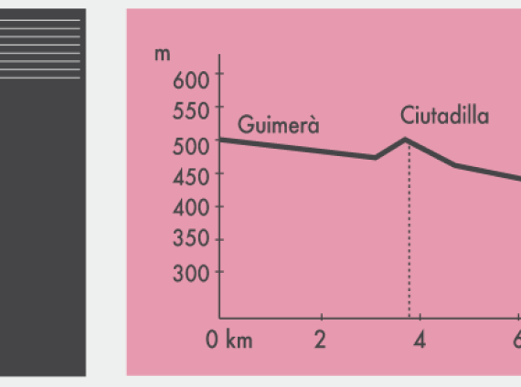
GR 3- QUART TRAM
Distance: 15.43 Km
Time: 3 h 43 min on foot
Slope: - + 160 m
12,700 We cross the bridge and, next to a fountain, we continue along the left bank of the Health Range
from the Corb river, leaving from the town (palo indicador).
13.750 Fork. Go to the right
14,050 New fork at 50m from a crossroad. We continue to the right along the edge of orchards and
vineyards On the other side of the river, we divide the ruins of the Sanctuary of Vallsanta and, further up,
the Sanctuary of La Bovera.
15,500 Bifurcation. We go to the left, going up.
16,050 Crossroads near a transformer. Go to the left (stick indicator).
16,800 Once the ascent rises, we enter Ciutadilla to Plaza del Marqués.
From here, on St. Miquel, it is advisable to go up to the castle that dominates this whole sector
of the valley. The GR-3 continues to the right of the square down the road.
17,450 Strong bend to the left. We continue straight on the edge of some cutlery (stick indicator). At 30
m going to the right, on the way to the river.
17,700 Corb River. We continue along the right bank, following a track on the left.
17,950 We pass under the bridge of the road. C-14 bordered by reeds and vines.
18,400 Waterfall. A small reservoir was used to collect water for a flour mill.
If the capital is abundant a beautiful waterfall forms.
19,750 Crossroads. We go to the left crossing the river. We are under Nalec.
19,950 New crossroads. To the left and 250 meters we would enter the beautiful village of Nalec. The GR-3
follow to the right.
20,800 Bifurcation. Go to the right
21,950 Church of Rocafort. It is advisable to trace the few streets of the town. Let's go down
on the Costa Street.
22,200 Highway LV-2016 (stick indicator near a scale). We continue straight ahead
South out of town.
22,380 Bifurcation. We go to the left in sharp rising. At 80 m we leave a path to the left
and we keep going up.
22,830 Bifurcation. We go to the left, bordering Tossal del Roc.
24,000 Bifurcation. Leaving first a path to the left and then one to the right. We continue
going up.
24,750 Bifurcation. Go to the right
25,320 Cruise after a climb. We continue straight ahead while planning.
25,570 Bifurcation. We go to the left while going down.
26,075 Crossing the Vilet road. We go to the left while going down (palo indicador).
26,530 Water tanks. Excellent view of the village of Vallbona de les Monges to ours
feet We continue to the right, a sharp descent.
26,950 Highway LP-2335 already in the village.
We go to the right and then we go down Carrer de Rocafort, carrer de Sta. Maria to get to
the monastery square.
27,530 Monastery of Vallbona de les Monges. Tel. 973 330 266.
| Attachment | Size |
|---|---|
| GR-3 | 143.81 KB |